THE BIG MAP OF THE EMPTY LAND
by Zeev Galili
A collector of ancient maps from Ramat Gan has an historical, treasure: a giant map prepared by a British survey mission at the close of the 19th Century, the scale is 1 to 63,000. The map proves that prior to the first Aliyah [wave of Jewish immigration] the Land was meager and empty. It verifies the Zionist claim: "A people without a land to a land without people"
I have discovered a treasure that the Minister of Education is invited to examine: a map of the Land of Israel, one of a kind, the biggest map of its era. This is a map that was prepared by a British research mission, who conducted a survey of the Land of Israel during the period 1871 to 1878. The scale of the map is 1 to approximately 63,000. Each centimeter on this map whose size is that of a large room, represents 630 meters in real dimensions. On the basis of this map one can determine which settlements existed in those years and their size. According to these details it is possible to estimate the size of the population there. This map is the most important document, to my mind, to prove the Zionist claim: "A people without a land to a land without people"
When does history begin
Arthur Koestler, the Jewish author and thinker, wrote in "Promise and Fulfillment" that the question of who is right in the struggle for the Land of Israel depends on the question of what one takes as the starting point of the history of this land. A believing Jew begins his count with our Patriarch, Abraham and the promise he was given ("For all this land that you see, I will give to you and your descendants forever"). As to this claim one of the websites of the PLO says that "the Jews claim that in some bible they were promised the land".
One can begin the history from the days of the Second Temple. Then it turns out that the Jewish population in the Land of Israel, according to various estimates, numbered some six million people. Relative to this claim the Palestinians have already said that the ancestors of the Palestinians — the Hittites and Amalekites — had a prior claim.
For our purposes, it would be important to begin the history precisely from the First Aliyah, and an examination of the question what the Jewish pioneers found here when they began to arrive in 1882. The claim is that the Zionists did not come to an empty land, as accepted by so many in the Israeli public domain. Not a few New Left historians and post-Zionists have contributed to this claim, which views the very establishment of the state as the "original sin" which needs to be atoned for. Even a Zionist historian such as Anita Shapira writes that Herzl was suffering from "color blindness" in his regard of the "native" population, "a view characteristic of European superiority and colonialism"
With this in mind, it is important to know who was here at the time of the First Aliyah and the population estimates.
No Palestinian People
In one of the PLO websites I found the claim that "The Palestinian People" numbered 529,500 souls at the end of the 19th Century.
Really a people?
No way, never was.
According to serious scholars (not PLO propagandists) it is accepted that in that period there was no Palestinian people, even theoretically. The population then in the Land of Israel was no different from Arab populations in the whole region — not in ethnic terms, not by language, and not culturally. Only the post-Zionist historian, Baruch Kimmerling (in his book "Palestinians, a People in the Making") advances the creation of the concept "Palestinians" to 1831.
The rest of the scholars are in agreement that Palestinian nationalism, which differentiates itself from wider Arab nationalism, materialized only in the beginning of the 20th Century.
Who and what did the men of the First Aliyah find when they reached the Land?
A Focus of International Interest
In the second half of the 19th Century the Land of Israel became a focus of international concern. The 19th Century was characterized by impressive archeological discoveries — the deciphering of the hieroglyphics on the Rosetta Stone by the French scholar Champollion; the uncovering of the ancient archway in Jerusalem by the American scholar Robinson (after whom the arch is named); the uncovering of the tombs of the kings in Jerusalem by the French scholar De Sulcy; the discovery of the monument to Mesha, the Moabite king near Nachal Arnon, and more.
All of these turned the Near East, and the Land of Israel, in particular, into a focal point for visiting archeologists, geographers, statesmen, clergymen, and tourists. Among the visitors were the men of the Palestine Exploration Fund, a British foundation for researching the Land of Israel, which created the map we are talking about.
Mark Twain in the Land of Israel
Among the many tourists who came to the Land during that period was also the American author Mark Twain. Twain was here in 1867, fifteen years before the First Aliyah. He described his impressions in a book as follows:
...We arrived safely at Tabor Mountain...the entire way we didn't see a living soul... There was hardly a tree or a shrub anywhere. Even the olive and the cactus, those fast friends of the worthless soil, had almost deserted the country...the Land of Israel sits mournfully in sackcloth and ashes. Hovering over her is the spell of a curse that has blighted her fields and imprisoned her essence in chains. The Land of Israel is desolate and deprived of love. The Land of Israel no longer belongs to this world of action. She is dedicated to poetry and tradition, a land of dreams... Nazareth is forsaken...Jericho is cursed... Jerusalem...a village of the wretched...
After such a description it would seem that there is only one question remaining: who and what was there in the Land of Israel? Although not so in the view of Benny Morris, the New Historian (who has seemingly reversed his stance) who writes in his book "Victims" that "it is possible that he (Mark Twain) was prone to exaggerate".
If Mark Twain exaggerates then a long list of travelers, Jews and non-Jews, who came to the Land of Israel during that period, are exaggerators and fabricators, since this description repeats itself endlessly,
With this in mind, there is great significance to the question, who were the inhabitants of the Land in that period and what were their numbers
How Many Were Here
This is not a question of statistics. Those who accuse us of settling in a land of a non-existent people, or that we dispossessed the "natives", need to show us how many "natives" were here and where they were.
The answer to these questions is fair game to oriental whimsy and the pseudo-science that serve these visionaries.
Yitzhak Ben-Zvi, the former President of Israel, one of the great scholars on the Land of Israel in the Ottoman Period, (in his book "The Land of Israel and its Settlement during the Ottoman Reign") gives details on a number of populations in the Land of Israel in the first fifty years of Ottoman rule (1525-1573). He found in the Constantinople archives data that had been gathered by five censuses made for tax-collection purposes. In these censuses there were 45-50,000 tax-paying households. According to Ben-Zvi's estimate these households would amount to about 300,000 souls.
This number says nothing about the population in the last quarter of the 19th Century. In the three hundred years that passed, the Land experienced quite a few upheavals — earthquakes, epidemics, locust plagues, raids by marauding bandits from the desert, and more. All of this during the rule of a thoroughly corrupt government that extorted the inhabitants to the very bone while not providing any services at all
Ben-Zvi does not mention any Arab population estimate during the First Aliyah and it is clear that he didn't have a reliable source for such an estimate. Benny Morris says that the number was some 400,000 souls. Morris relies on the German geographer, Alexander Schulz, who wrote a book on the subject based on a variety of methods in order to arrive at a population number, lacking a reliable or authoritative source. Schulz, himself, notes (in an article he seemingly wrote after the publication of his book) greater numbers yet and small wonder he is a Palestinian favorite, who frequently quote him on their websites. Morris, in another context, also relies on the Scots scholar, Justin McCarthy, who is also generously quoted by the Palestinians. McCarthy lists very large numbers. He determines that in 1860 there were 411,000 Palestinians and in 1890 there were 553,000. Joan Peters, the author of "From Time Immemorial" estimates that at the beginning of the First Aliyah in 1882 there were about 141,000 non-Jews, and approximately one quarter of them were immigrants who had arrived in the Land in recent years, primarily during the Egyptian conquest. This occupation lasted from 1831 to 1840 during which the Egyptian conqueror initiated mass immigration from Egypt to the Land of Israel. These immigrants were brought to Gaza, Bet She'an, Nablus, Acre, and Jaffa.
Professor Moshe Maoz arrives at a much smaller estimate for the Ottoman period. In his article written for the book "The History of the Land of Israel" he notes that as a result of the actions of the Ottoman rulers and the poor hygienic conditions, the population of the Land of Israel was in a constant state of decline and during hundreds of years the number of Arabs did not exceed 100,000.
To summarize: There is, in fact, no well-founded estimate of the number of non-Jews in the Land of Israel at the onset of the First Aliyah, although it is reasonable to assume that the population was small. If the lowest estimate is correct, i.e., there were about 100,000 Arabs in 1878 (the year in which the survey of the British Expedition ended).
How the Map was Made
The Foundation of British Exploration of Palestine" created in 1865 by the elite of the British upper class of the time, Lords, academics, clergymen, and the very wealthy. The fund set up its goal to conduct researches in the fields of archeology, history, geography, and ethnography in what was then called "Palestine".
The expedition numbered several dozens of people, among them expert cartographers, and heading it were well-known people: [Sir Charles] Warren, [Claude R.] Conder, [Horatio H.] Kitchener. The project was begin in 1871 and completed in 1878. The production of the printed map lasted several years, and when it appeared it became the most detailed precise map of the Land of Israel. Due to its size, the map was printed in 26 separate sections, in four colors, by lithography.
Imaginary Maps
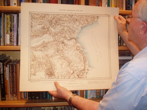
Dan Yardeni is the owner of a copy of the map here in Israel. He is an engineer, manager of a start-up, and, in essence, loves the Land of Israel. He began to collect ancient maps of the Land of Israel in his youth and his workroom looks more like a wing in a museum than the office of a large company's manager.
Yardeni is a fascinating walking encyclopedia. A collector of an amazing range of maps and Judaica, and thoroughly knowledgeable in the field. Most of the ancient maps of the Land of Israel, he tells me, are really not maps in the ordinary meaning of the word. They are not exact, contain artistic elements and, quite often, based on imagination. For instance, he has a map by a cartographer named Pontius from the 17th Century that depicts drawings of historical events from various periods. The cartographers of that time did not really know the land. Thus, one of the maps depicts a river connecting the Mediterranean Sea with the Sea of Galilee. On another map we see that the Jordan [River] has a source named Dan and another named Jor. The cartographers assumed that if for one section of the Jordan there was a source named Dan, then the second source must be called Jor.
The British Survey map "I acquired in a bookstore in London at a bargain price. They didn't appreciate its importance or value. Today it is worth many thousands of dollars", said Yardeni.
What we Learn from the Map
The uniqueness of the map is that the British surveyors marked with great accuracy the borders of every settlement and noted in special colors the populated sections of the settlement. It is possible through this map to ascertain the size of each settlement in the Land during that period, from the L itani River in the north and as far south as Beer Sheba.
The map represents by cartography what Mark Twain described in a literary form: a desolate arid wilderness, almost empty. Using a ruler it is a simple matter to determine the size of each settlement. When examining the villages we see that their areas are tiny. The largest of them are 150 by 100 meters. They comprise barely two rows of houses. The color legend indicates that Acre, for example, was then only partially inhabited. Entire areas were empty of people, exactly as we had learned in school, and likewise the Jezreel Valley and the Jordan Valley and all the areas that the Jewish pioneers later brought to life. (Benny Morris, in his book, says that the Zionists that redeemed the Jezreel Valley deprived land from the Palestinians for their development)..
Haifa is marked on the map by a rectangle of three by seven millimeters. Each millimeter represents 63 meters in actual terms. This means that the Haifa area was 190 by 440 meters in size. The German Colony is outside the Haifa perimeter, and each house is exactly drawn
Nazareth was then a little larger than Haifa. Its shape is in the form of a gourd whose longer end is 600 meters and its smaller end some 300 meters. Even Tiberias is larger than Haifa — 300 by 600 meters. "Greater" Jaffa was only a little town — 240 by 540 meters. Shekh Munis, where the Tel Aviv University now stands, was a tiny village 90 by 180 meters. So, also, Usfiyeh, Yehud, and many other villages.
Jerusalem, within its walls, was, in fact, large — 1000 by 1000 meters. There was nothing outside the walls, and we know (not from the map) that within its walls there was always a Jewish majority.
ADDENDUM
From http://www.zeevgalili.com/english/2009/02/a-treasury-of-photographs-of-empty-palestine/#more-131
Hundreds of rare photographs from the 19th Century reinforce the conclusion emerging from the British Expedition's map. The photographs were painstakingly collected by Eli Shiller, a Land of Israel researcher, and they can be viewed on the internet. This too is the opportune time to determine which of the terrorist leaders is actually a Palestinian
When I published the article on "The Great Map of the Empty Land", I had difficulty in finding photographs that would support the conclusion arising from that map.
The map — which was drawn up by a British Expedition that made a comprehensive survey at the close of the 19th Century — proves beyond the shadow of a doubt that the people arriving in the First Aliyah (1882) found a desolate and empty land, exactly as the author Mark Twain and many other tourists had described.
There is an abundance of beautiful etchings of that era in travelogues. The problem with these etchings is that they reflect more about the romantic notions of the etchers towards the landscape and people of the "Holy Land" than the actuality. In Mark Twain's book there are several photographs, but they are of such poor quality that they are not helpful. So, also, are photographs of that period from other sources, among them the photographs appearing in the books of the members of the British Expedition.
It's all a matter of luck akin to that of a Torah Scroll in the
Holy Ark [a Hebrew reference to the arbitrary-like decision of
which of the scrolls is the "lucky" one to be chosen for a
service]. And if so for a Torah, how much more so, and no actual
comparison intended, for a column in a newspaper. It was a matter
of luck that one of my readers, Yoav Rophe, brought to my
attention the fact that a website existed in which there was a
great treasure of photographs of Eretz Yisrael from the 19th
Century. For those readers who cannot resist I will list the
website right here. After having seen their fill of these
treasures they can resume reading my article. The address of the
website is:
http://www.eretzyisroel.org/~dhershkowitz/index.html
A retired newspaperman, Zeev Galili was a City Editor and Deputy Chief Editor of Yediot Ahronot, Israel's highest circulation daily newspaper with a readership of 600,000.
He authored twenty children books and ghost written books and biographies to many politicians and business people.
Born in 1936 in the Galil town of Tsfat, he is of the seventh generation of his family to be born in Israel. His family was among the founders of Rosh Pina in the Galil region.
This article was posted February 10, 2009 by Zeev Galili on his
website and is archived at
http://www.zeevgalili.com/english/2009/02/the-big-map-of-the-empty-land/#more-5.