| THINK-ISRAEL |
| HOME | Mar-Apr.2005 Featured Stories | Background Information | News On The Web |
Except perhaps in a rain forest, deciding who controls the water supply has been a major direct and indirect reason for hostilities between neighbors since ancient times.
In the Holy Land, there is a long history of water disputes way back to the time when our fathers Abraham and Isaac were digging wells for water for their flocks, wells that were subsequently seized by the Philistines[1] based around the present-day Gaza strip under their king Abimelech. Eventually Abraham and Abimelech entered into a treaty in which Abraham promised that his descendants would not attack the Philistines. This did not stop the Philistines from stopping up or confiscating Isaac's wells nor from attacking Israel during the period of the prophets.
Particularly in the Middle East, water can never be ignored. So it is surprising that in all the discussions for and against disengagement from Gaza as a first step in withdrawing from (some/most/all of) Samaria and Judea (the West Bank), water has been mentioned so rarely.
As almost everywhere else in the world, Israel's ultimate source of water is natural rain fall. Direct rainfall determines if a region is dry or wet. Israel is a dry area, with rain falling only in the winter months, and half of Israel receiving minimal amounts of rain. The amount of rain Israel receives depends on world-wide as well as regional factors. So from year to year, the amount of rainfall is variable and unpredictable, except we can safely say it is more often low than high. Gisser and Pohorlyes[2] write:
"In an average year rainfall over Israel is estimated to be 5 x 10⁹ m³; about 3.5 x 10⁹ m³ of this is lost through irretrievable absorption evaporation, leaving only 1.5 x 10⁹ m³ per year to reach the country's water reservoirs on the surface and underground"
The manner in which the land and its lakes and rivers take up and hold rain determines utilizability. Israel's major surface reservoir is Lake Kinneret (the Sea of Galilee). Its major river is the Jordan.
The Kinneret is a freshwater lake some 165 square kilometers in size and around 200 meters below sea level. Its level of water was below danger level for many years. It holds around 3 billion cubic meters of water and serves as the major reservoir of the National Water Carrier (also known as the Kinneret-Negev Conduit).
The Jordan is Israel's largest river. It flows through the drained Hula Basin into the freshwater Lake Kinneret; and from the southern end of the Lake, it flows out to end in the highly saline Dead Sea. It forms the boundary between Samaria and Judea in Israel and Jordan.
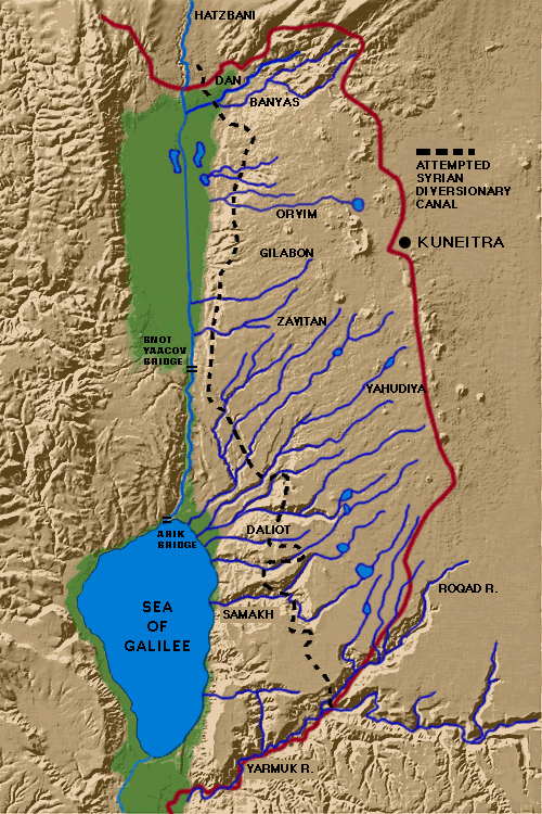
These are the sources of the Jordan and Lake Kinneret. (Click here to view a map showing them.)
Barbara Elmore[3] makes clear why water storage is so important.
"The rainfall of the region is not uniformly distributed over the year--hence there is a premium for storage of runoff when it occurs. In the north, where rainfall is relatively heavy, Lake Kinneret/Lake Tiberias/Sea of Galilee serves this purpose. In the more arid south, where surface reservoir sites are subject to large water losses from evaporation, subsurface storage has been used extensively. In ancient times, local cisterns were widely used, and this is still a valuable method for developing storage. Artificial recharge of ground water is another method that is currently in use in several places."
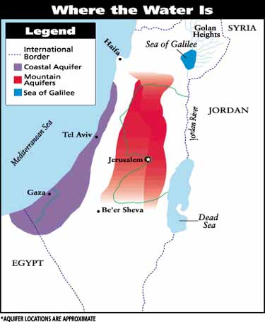
Israel natural water storage areas are the Kinneret and two aquifers: the Coastal Aquifer, and the Mountain (Yarkon-Taninim) Aquifer.
A. The Kinneret
For the most part, immediately usable water is stored in the Kinneret (the Sea of Galilee). The Kinneret is Israel's major surface reservoir.
Because of Israel's small size, on a map the Kinneret appears to take up a large area, but in actually, it is more accurately described as a small lake than as a sea.
The role of the Kinneret in acting as a buffer for Israel's open water channels has been extensively documented. Michelle Stirling-Anosh, a writer and researcher who lives in the Golan, provides us with an excellent summary.[4] She notes that in addition to supplying Israel with much of its fresh water and agricultural and irrigation water,
"[t]oday, the 'Sea' is being called upon to also supplement water supplies to Jordan and the Palestinian Authority. And today, the Syrians are demanding possession of the headwaters of the Sea of Galilee as part of a potential peace deal, yet most of the Sea of Galilee's water sources are located in the Golan Heights."From the point of view of many experts, there is a serious danger to regional environments and water quality in turning the Golan Heights, the valuable source of the Sea's supply, over to Syria - a nation which has repeatedly violated International Water Treaties with Jordan and Turkey, and which, according to the CIA's World Fact Book, has a serious problem with domestic water contamination and inappropriate water use."
B. Aquifers
The Kinnert is supplemented by two aquifers - subterrian storage areas. Aquifers are natural water-bearing geologic formations, which because of their porous structure and occurrence beneath more solid rock formations are able, not just to absorb water, but to hold it for long periods of time. Access to the water within an aquifer usually requires sinking a well. The necessary depth of the well varies largely by the water pressure within the aquifer and the depth of solid rock overlying the formation. Direct collection of rain water as opposed to rain held in aquifers is a relatively minor source of Israeli water.
In Israel, natural subterranian water aquifers occur in two major groupings: the Coastal Aquifer and the Mountain Aquifer. To view a map showing the location of the aquifers, click here.
The coastal aquifer lies underneath the Mediterranean coastal plain in Israel, from southwest of Gaza inside Egypt into Israel, between Rafah in Gaza and Mount Carmel. It has an estimated water potential of approximately 250 millions of cubic meters (MCM) per year.
The mountain aquifer lies primarily underneath Samaria and Judea - especially Samaria. It consists of three basins: the west, northeast, and east. Let me underscore that: 83 percent of the recharge areas for these basins lie in Samaria and Judea - areas destined for the chopping block, once Gaza is cleansed of its Jews. To date, access to these basins can be had in Israel where the water emerges in natural springs, but why would Israel even consider trusting this most precious resource to the good will of the Palestinian Arabs, who have no restrictions on drilling new wells?
The underlying rock of the Golan is largely basalt and as such has very poor water-holding properties. This failure as an aquifer is the cause of the many beautiful gushing streams - so characteristic of the Golan - streams that are tributaries to the Jordan River.
Yedidya Atlas, a senior correspondent and commentator for Arutz-7 Israel National Radio, connects water usage to water supply.[5] He writes:
"A series of extensive studies conducted by geologist Martin Sherman, author of "The Politics of Water in the Middle East," [MacMillan Press, 1999] indicate that the permissible output of these sources varies from year to year, according to the annual rainfall. This varies from 600 to 800 million cubic meters per year. Current non-agricultural demand (e.g., showers, coffee, chicken soup, etc.) has reached the level of 600 to 700 million cubic meters. In other words, Israel's current population needs virtually the entire permissible annual output of both the surface and underground water reservoirs that make up the National Water System. We see, then, that the necessary quantities of water required by the agricultural sector can only be supplied by over-exploiting the system and reaching the danger levels."As a result, Israeli agriculture has become increasingly dependent on recycled sewage and other types of low-grade waters which are unsuitable for drinking. Hence, the oft-repeated argument that Israel's water crisis can be resolved by reallocating water used by the agricultural sector to the non-agricultural sector sounds good, but is simply untrue - unless we are to drink these low-grade waters.
"Moreover, while the population increases, the water supply is actually shrinking. This is due to a deterioration of both the quantity and quality of the country's water resources. As Sherman's study logically stipulates, "the diminishing quantities and deteriorating quality in one water source inevitably increases the importance of other sources in the system."
Israel has had some considerable experience in what happens when she loses control of a major water resource. Since Oslo, Israel has shared the Mediterranian Coastal Aquifer with the Palestinian Authority. Not surprisingly, the aquifer has become an egregious example of salination. Haim Gvirtzman[6], writing in 1998 warned:
"After the IDF's withdrawal from the Gaza Strip, some 500 new wells were drilled there, in violation of the agreement reached with the PA, and today many attempts to drill wells are being made in the Jenin area. The vital need to prevent wildcat drilling by Palestinians and the need to ensure the supply of good quality water in the future requires exclusive Israeli control of the vital pumping areas."
By 2003, geochemist Avner Vengosh of Ben Gurion U. in BeerSheva wrote that it was "... quickly becoming contaminated with salts, nitrates, and boron, with many wells already exceeding international health standards..."[7]
Atlas[8] underscores this point and its consequences on water usage.
"Specifically, there is deterioration in the Coastal Aquifer, where "the level of salting and other pollutants has reduced the quality in numerous sites to below that permissible for drinking water. A similar pattern has begun in Lake Kinneret as well, albeit to a lesser extent."
Can we expect better from the 'new' Palestinian Authority, given their unchanged record of municipal mismanagement, poor planning, insufficient knowledge or policing, and just plain neglect? Atlas points out that:
"[w]hen Gaza was turned over to the sole ruling authority of Arafat's PA, it received total control of the Gaza aquifer - which at the time was still functioning and producing potable water. Within less than two years under Palestinian Arab management, the Gaza Aquifer was ruined, contaminated beyond repair. If the PA is incapable of taking care of its own aquifer to supply water to its residents, how can Israel place its trust in the same Authority to care and conserve water sources that supply Israeli taps?"
The Coastal Aquifer extends south to include all of the Gaza strip as well as the site in the Sinai where once Israelis built Yamit. Abandonning the coastal tail of the aquifer to the Egyptians - thus reducing Israel's water supply - compounded the damage to the aquifer by present-day overutilization. The remains of Yamit are a memorial - and a warning - of the first expulsion of Jews by Jews.
Atlas also points out the consequences of Israel's allowing the Mountain aquifer to fall into Arab hands:
[Given what has happened to the Coastal aquifer] "the importance of the Mountain Aquifer has increased. As Israel's State Comptroller's Annual Report already reported by the early 1990's:"The Mountain Aquifer, extending eastward of the Coastal Aquifer, from the slopes of Mt. Carmel to Beersheba, and from the crests of mountain ridges in Judea and Samaria to the coastal plain, serves as the principle reservoir of drinking water to the Dan region, Tel Aviv, Jerusalem and Beersheba. Today, it is the most important long term source in the [National] Water System.""Now comes the political problem. This 'most important long-term source' physically straddles the pre-1967 cease fire lines, alias 'the Green Line', into Judea and Samaria. The Principle of Connecting Vessels tells us that any activity affecting the water on one side will affect that on the other side as well. So if pumping operations, or uncontrolled flow of sewage or industrial waste, etc., occur on the western slopes of Judea and Samaria, it would cause serious, and most probably irreversible, damage to the key source of drinking water for Israel's major urban centers and environs.
"The political and strategic significance for Israel is clear. Withdrawing from Judea and Samaria - i.e., the Mountain Aquifer - or from the Golan Heights would create a situation in which the fate of Israel's water supply would be determined by Mr. Arafat's Palestinian Authority and the Syrians, respectively. [underscoring added]
"Can Israel really afford to trust her most valuable and irreplaceable national resource in the hands of those who have had a long history of trying to destroy the Jewish State? In the case of the Syrians, this includes diverting and/or poisoning Israel's water supply."
Whether through malevolence, ignorance or seeing the Middle East through Arab-colored glasses, much of the press presents a distorted picture of water usage between Israel and the Palestinian Arabs, wherein Israel is the villain. In the summer of 1998, as an example, the New York Times compared how the West Bank Arabs were "parched" for drinking water while the Jewish settlers near Hebron watered lawns and washed cars.[9] The Times knew exactly how incendiary the story was - accuracy wasn't its objective. The facts were much different - the settlers needed to drink bottled water because they didn't have drinkable water while the Arabs don't distribute their water equitably but sell their water privately or steal it and then sell it.
What goes unreported is the extent to which Israel shares water with her neighbors. Camera[10] pointed out in 2002 that
"... every year over 40 MCM (million cubic meters) of water from sources within Israel is piped over the Green Line for Palestinian use in the West Bank. Ramallah, for example, receives over 5 MCM. Israel sends another 4 MCM over its border for Palestinian use in Gaza. Thus, it is the Palestinians who are using Israeli water."And not just the Palestinians. Despite its own meager supply, Israel annually provided 600,000 CM of water to ten otherwise dry villages in South Lebanon, and provides more than 55 MCM annually to Jordan."
"In addition, Israel also supplies more than 4 MCM annually to the Gaza Strip through the Kissufim Line of the National Water Carrier, serving the Palestinian localities of El-Bureij, Moazi, Abasan, Bani Suheila and Khan Yunis" (Statistical Data on Gaza Area and Jericho, Israel Foreign Ministry, June 1994).
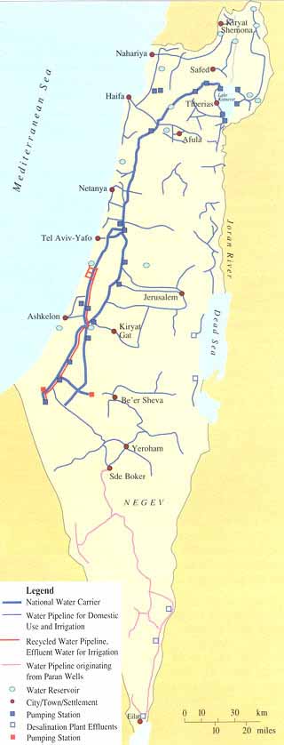
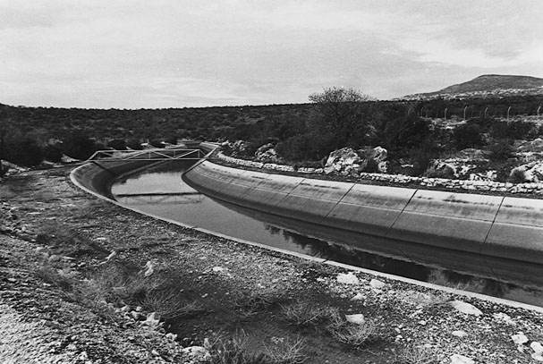
The waters of the southern Jordan are inaccessible to Israel because of the mountain ranges of Samaria and Judea. So water must be physically delivered to the southern part of Israel. Water is delivered from the north - Lake Kinneret is as a major resource - to the northern Negev and to parts of Arab Gaza by a interconnected network of pipes, aquaducts, tunnels, canals and dams known as the National Water Carrier. Water is also transported by the pipeline to recharge the underground aquifers in the coastal region and to transport water from the coastal and mountain aquifers. To view a map showing the transport system, click here. And you can see a photgraph of a section of the pipeline by clicking here.
If Israel splits itself into two separate sections - a necessary consequence if Secretary Rice's proposed Palestinian Arab state is to have contigous segments - the pipeline will be passing through Arab Palestinian territory. This is likely - as will the loss of air space control - to result in blackmail and sabotage.
The National Water Carrier was developed by Israel after Jordan with Syrian assistance had build its East Ghor Project, which served the eastern bank of the Jordan with water. Israel's independent action, although legal, was opposed by the Arab states in general. There were All-Arab schemes to divert water from the Yarmouk, which would have seriously diverted Israeli water supply. As Barbara Elmore notes [11]
"Between 1964 and 1967, these political clashes developed into several military confrontations between the Syrians and the Israelis. Other than the bombing of the East Ghor Canal later in 1969, this time period involved the most direct water-related conflict. The most notable incident was the destruction of the diversion works on the Banias-Yarmouk Canal in Syria by the Israeli Air Force in July 1966. Israel destroyed the All-Arab diversion plan that would have reduced Israeli water supplies by 35 percent"
This lesson in history makes clear what we can expect if Sharon is allowed to carry forth out his plans for delivering large chunks of Israel into Arab hands.
The basis of Israel's water problem is graphically illustrated in this table[12] in which the contributions of the various components are shown in an input-output description of water distribution and use. The Annual Recharge column is the limiting factor governing judicious use of the absolutely essential renewable resource. If the total water use (Col 6) exceeds annual recharge (Col 2) for any significant length of time, irretrievable damage to the aquifer will result. Furthermore, reversal of this damage can take decades or even centuries to accomplish, even under the best of conditions.
The Gaza aquifer is the part of the Coastal Aquifer basin under the Gaza strip. The Gaza aquifer problem is underlined by the table. The annual recharge of the Gaza aquifer (Col 2) is far less than Palestinian Arab water use (Col 5). It is further evident that the settlements in Gaza use less than 10% of the total water use (Col 4). Ironically, Israel's commitment to supplement the Gaza Arab water supply will continue, even after withdrawal, but she will have neither political or environmental control over the unrestrained extraction of water from an already damaged aquifer at the hands of Arabs, many of whom have refused to cooperate in preserving the natural resource.
| Water Resources | Annual Recharge | Israeli Water Use | Settlement Water Use | Palestinian Water Use | Total Water Use |
| Mountain Aquifer | |||||
| Western | 362 | 344 | 10 | 22 | 376 |
| Northeastern | 145 | 103 | 5 | 30 | 138 |
| Eastern | 172 | 40 | 35-50 | 69 | 144-159 |
| Coastal Aquifer | 250 | 260 | 0 | 0 | 260 |
| Gaza | 55 | 0 | 5-10 | 110 | 120 |
| Jordan River | 1311 | 685 | 10-20 | 0 | 1334-1340* |
| Wastewater | 450 | 450 | 0 | 0 | 450 |
(* Some of the Jordan flow is siphoned off by Jordan and Syria in accordance with existing agreements with Israel.)
One can only conclude that Israel is balanced on the razor's edge of its water economy.
It's time Israel's water supply is taken out of the hands of the politicians.
During a debate at Tel Aviv University's Diplomatic Forum, when challenged on how, after disengagement from Northern Samaria (which overlies hydrologically crucial areas of the Mountain Aquifer), Israel will be able to continue to manage and preserve its national water system, Dov Weisglass - Prime Minister Sharon's crony and mouthpiece - admitted with some embarassment that he did not really undertand much about water problems and added flippantly, to the astonishment of the audience (which included many foreign embassy staff), "maybe we'll have to import bottles of water."
This all goes to underscore that the proponents of the disengagment have not even devised way to contend with the easily predicted (and therefore probable) scenarios, let alone the unexpected (and unpleasant) surprises that are as yet unforeseen.
But even politicians can not exist on champagne alone.
Judging from past experience, Israel can not afford to allow her already stretched water supply to be put under the control of the Arabs - not if she expects to survive and thrive.
It would almost seem as if the Arabs have been reading the maps and the Israeli politicians haven't.
Much of the major underground stores of Israeli water is in YESHA - in Gaza, in Samaria and in Judea. Yet plans are already underway to make Gaza Judenrein. And when that has been taken care of, the Israeli Government - this time, not even for a piece of peace paper - will kick the Jews out of large parts of Samaria and Judea. The impact on "Israel proper" has been ignored. Aside from Israel's physical loss of much of the land on top of the aquifers, it means that Israel will be separated by an Arab terrorist state - de facto or de jure - from the Jordan river.
The Arabs are no stranger to trying to capitilize on aquifers. For example Arab militias in the Sudan are terrorising (mainly Christian) Sudanese out of their land an villages, primarily because of a vast water-aquifer under the region. Their enjoyment of violence and rape, and their hatred of the local Christians, is a secondary reason. In Israel, there has been a proliferation of illegal overdrilling to the subterranian aquifers in Arab areas of the West Bank and this has already resulted in salination of the ground waters. The Arabs both voluntarily and involuntary pollute Israel's ground water and let raw sewage flow through the porous surface to the aquifers.
Nor are the northern sources of fresh water to the Jordan river safe from the politicians. Syria continues to agitate for the Golan and as recently as 2000, the then Prime Minister Ehud Barak was more interested in a piece of paper of peace than in the physical survival of the Jews. The sources of the Jordan river are in the Golan. And one keeps hearing of current not-so-secret meetings between Israel and Syria, whose end result of course will be that Israel gives and Syria takes.
Should Israel trust the Arabs to be "good neighbors"? Not if past experience is any indicator. As was cited above, the Syrians have made repeated efforts to deviate water from the Yarmouk, normally destined for Israel, to their own uses. (See the first map, which shows the sources of Lake Kinneret and the Jordan river. The heavy dotted line indicates the "attempted Syrian diversionary canal".) This has resulted in brief armed conflicts in which the Arab intentions have been frustrated. Much has been made in the international press of these 'incidents' - mostly castigating Israel - but, in fact, Israel has acted strictly under the terms of the Armistice following the Yom Kippur war.
Consider, too, the environmental factors which have not been given sufficient weight in talking about the Golan. This from Anosh:[13]
"After the Six Day War in 1967 when Israel took possession of the Golan Heights, it found the land, water resources and wildlife to be undeveloped and unprotected. Though there had been some Syrian settlements, land cultivation was manual and done on small plots of land. There was no sewer infrastructure. Much of the territory had been mined. All of the wild deer had been hunted to extinction. Many other wild species had been hopelessly depleted."
To be fair, Israel's record on water pollution and the ecology has not always been good. But as Shoshana Gabbay writes, "River rehabilitation in Israel is no longer a dream; it is a reality."[14] Things are not perfect. For example, because of bureaucratic gridlock between Israel's Ministry of the Environment and its Water Commission, regulations to reduce pollution from leakages from the oil pipe lines that crisscross the country have not been put into place. As noted in a case now pending: "Leaking fuel seeps into the soil and beyond, with just one liter of leaked oil capable of contaminating one million liters of groundwater."[15] But it is certain that under the present regime, when Israel gives the Arabs control over much of Israel including the underground aquifers, whatever surveillance there is over oil pipe leakage and illegal drilling for water will be gone. When the decision, formulated while Netanyahu was prime minister, to give about 97 percent of the Golan to Syria is again adopted, Israel loses the water from the Banias. Sharon has been keeping this plan under wraps.
In the 60's the Syrians attempted to divert the Banias River, then inside their borders, but this was stopped by the IDF. After the capture of the Golan Heights this danger to the water supply was, for the time being, averted. But ever since the late 60's the governments of Israel have been lax about the water supply (as they have been also about illegal squatting on state land by Arabs). Yitzchak Rabin, while Prime Minister, decided not to act over Lebanese interference with Israel's water (besides issuing a useless formal complaint) and subsequent governments have kept his policy. The Lebanese have also been polluting the water flowing towards the Kinneret with untreated sewage.
Thus, 80% of the water supply of Israel has been intermittently but repeatedly threatened by accidental and intentional pollution and illegal diversion. The figure of 80% represents the 30% of the water supply that comes from the Golan and the 50% is derived from waters with Syrian sources, especially the Yarmouk.
In the 90's there was a 'peace' treaty between Israel and Jordan. In 1997 Israel irresponsibly agreed to provide a large amount of high-quality water to Jordan, irrespective of the state of her natural water supply and paying no regard to possible droughts. Consequently, Israel had to buy water to deliver to Jordan.
It is always an Israeli prime minister, starting with Menachem Begin and so far ending with Sharon, who leads the way in making offers to withdraw from much more territory than the Americans were even dreaming of. Of course America then takes this land as surrendered and supports the Arabs' demands for more. The government is now following the Leftist fifth column Peace-Now in claiming that the Israeli occupations are illegal. The Golan has been annexed but this does not mean it cannot be de-annexed. The present government holds that even though the West Bank was captured in self defence its occupation by Israel is illegal.
In all, Israel could lose control of more than three quarters of its present supply of water, from rivers, from rainfall in the West Bank and from the water aquifers. The heirs to the kibbutzim are not worried. They have largely given up on agriculture and diverted to industry. This requires less agricultural land and water. Factory farming is an industry and not agriculture; their food production needs only barns and cages for poultry and stalls to imprison the cattle and pigs.
In about 50 years it is predicted that a sizeable proportion of present Israel will because of global warming be under sea-level and the strife for land and water will increase.
In those same 50 years, the demographic projections for the combined Jewish and Arab Israeli growth put an impossible burden on the diminished water supply.
Actually the prime minister does not seem to care a hoot. He seems to despise naturally obtained water. He wants to rely on his grandiose schemes, viz., expensive, environmentally unfriendly and dangerous desalination using nuclear power, on other hydro-electric projects and on pipelines. At the moment, reverse osmosis is touted as saviour. Aside from the fact that getting water even from the first of the desalination plants continues to be in the future indefinite, it doesn't remove more than 60% of the boron, a major contaminant of the Mediterrian Sea. The environmental cost of his Red Sea/Dead Sea desalination project includes overloading the Dead Sea. The same goes for his dream-solutions of buying water from Turkey and Norway or transporting water from the Nile. All these projects are economically, environmentally and politically unsound. Leaving Gaza is also militarily unsound; the Ashkelon desalination plant - located a few miles from Gaza - is almost impossible to defend from rocket attack when Israel is outside of Gaza[16]. These schemes make Israel dependent on the goodwill of other countries and on the friendliness of the Palestinian Authority.
Bad strategy. Bad tactics. Bad for Israel.
1. The Philistines were neither Ismaelites nor Cana'anites, but a people from Caphtor, presumed to be Crete, who came into the area maybe via northern Egypt. Their descent is probably from Japhet.
2. Gisser, M., and S. Pohoryles, "Water Shortage in Israel: Long-Run Policy for the Farm Sector," Water Resources Research, 1977, 13 (6): 865-72.
3. Barbara Elmore, "Middle East Water Issues: Nine Lessons
Toward Peace," 2001,
www.uh.edu/hti/cu/2001/v05/02.htm
4. Michelle Stirling-Anosh, "Water, the Golan and the Sea of
Galilee," January 16, 2000,
www.gamla.org.il/english/article/2000/jan/water.htm
5. Yedidya Atlas, "Israel's Water Basics," March 21, 2002,
www.israelforum.com/board/archive/index.php/t-342.html,
6. Haim Gvirtzman, "Maps of Israeli Interests in Judea and Samaria Determining the Extent of the Additional Withdrawals," 1998, (http://www.biu.ac.il/Besa/books/maps.htm#4).
7. "Water on the Gaza Strip: Time Bomb or Ray of Hope,"
November 7, 2003,
http://www.geosociety.org/news/pr/03-34.htm
8. See footnote 5.
9. Andrea Levin, "West Bank Water and New York Times
Stereotypes," September 1, 1998,
www.camera.org/index.asp?x_article=125&x_context=2
10. CAMERA, "Does Israel Use 'Palestinian' Water?,"
world.std.com/~camehttp://world.std.com/~camera/docs/backg/water.htmlra/docs/backg/water.html
11. See footnote 3.
12. "Geography of Water Resources,"
Woodrow Wilson School of Public Policy and International Affairs, 1999,
http://www.wws.princeton.edu/~wws401c/geography.html
13. See footnote 4.
14. Shoshana Gabbay, "Restoring Israel-s Rivers," January 1,
2002,
www.mfa.gov.il/MFA/MFAArchive/2000_2009/2002/1/Restoring%20Israel-s%20Rivers.]
15. "Pollution from oil pipelines," December
2004,
http://www.iued.org.il/page.aspx?pid=73&cid=0&menu=6
16. Nina Gilbert, "Disengagement puts strategic facilities in the crosshairs," Jewish news weekly of northern California, January 14, 2005.
Aubrey Wulfsohn is at the Warwick Mathematics Institute in Coventry,
England.
| HOME | Mar-Apr.2005 Featured Stories | March 2005 blog-eds | Background Information | News On The Web | Archives |